Category: Construction Software

  • From Over-Ordering to Supplier Accountability: How Drones Redefine Stockpile Management

    From Over-Ordering to Supplier Accountability: How Drones Redefine Stockpile Management

    Having spent years in the commercial construction industry, I’ve seen firsthand how the integration of drone technology and advanced post-processing software has revolutionized site management. Accurate stockpile measurements are essential for staying on schedule and within budget, but the real game-changer isn’t just the drones collecting data—it’s the sophisticated software that processes it into precise, actionable insights.

    Construction Supervisor Taking Materials Inventory
    Managing materials stockpiles can be a time-consuming and error-prone process.

    Traditionally, managing materials stockpiles was a manual, time-consuming and error-prone process. Workers had to physically measure stockpiles, often with basic tools or outdated equipment, and then calculate volumes manually. While functional, this method left room for costly errors. Human oversight, difficult terrain, and sheer site complexity made inaccuracies inevitable. But with the advent of drones and cutting-edge software, we’re solving this problem at its core.

    The Limitations of Traditional Stockpile Management

    A few years ago, a construction manager I worked with discovered a significant discrepancy between their manual stockpile measurements and actual inventory. This discrepancy wasn’t caught until midway through a critical phase, leading to a materials shortfall. Rushed orders from a supplier not only cost a premium but also caused delays that rippled across the schedule. On top of that, the supplier had overbilled them in the past—errors they didn’t realize until after adopting drone-based measurements.

    Construction Subcontractor Holding Clipboard
    Rush orders from a supplier not only cost a premium but also caused delays that rippled across the schedule.

    This is a common scenario in construction. Without accurate and timely data, it’s difficult to spot errors or hold suppliers accountable. Over- or underestimating stockpile volumes can lead to either overordering, which ties up capital and space, or underordering, which disrupts progress. Either way, the project suffers.

    How Drones and Software Work Together

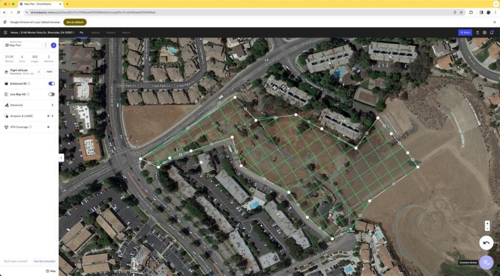
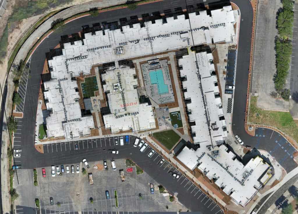
    Drones bring speed and efficiency to data collection. They can quickly fly over a site, capturing high-resolution aerial imagery of stockpiles from multiple angles. But the real magic happens in the post-processing phase. Using advanced software, this imagery is transformed into orthographic images—highly accurate, to-scale maps of the site. From these images, the software generates precise 3D models and calculates stockpile volumes with unparalleled accuracy.

    This process eliminates the guesswork. Instead of relying on rough estimates, project managers now have a reliable, detailed view of their materials inventory. The combination of drones and post-processing software ensures that every measurement is precise, helping teams make informed decisions about ordering and allocation.

    The Benefits Go Beyond Accuracy

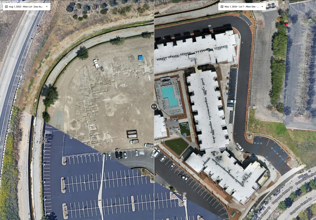
    Regular drone flights, coupled with software processing, also create a digital timeline of site progress. This visual record allows project managers to monitor the movement and depletion of materials over time. It also provides stakeholders with transparent updates, fostering trust and collaboration.

    Moreover, the post-processed data isn’t just useful for measuring materials. The orthographic images and 3D models can be integrated into broader project management tools, helping teams plan and coordinate everything from equipment placement to site safety measures.

    A Smarter Approach to Construction

    One of the most rewarding aspects of my work is seeing the tangible benefits of these technologies. I’ve worked with teams that saved thousands of dollars by identifying discrepancies in supplier invoices using drone-generated data. Others have avoided costly delays by catching stockpile shortages early.

    The combination of drone technology and post-processing software is transforming construction site management. It’s not just about having the latest tools—it’s about empowering project managers with the information they need to make smarter decisions.

    If your site is struggling with inaccurate stockpile measurements, delays, or supplier disputes, it’s time to consider a more advanced approach. Drones and software don’t just make the process easier—they make it better. Let’s put them to work on your next project.

    From The Editor:

    Do you need to hire a professional drone service provider for your project?  To speak to an aerial data specialist, fill out a form, email us or for even faster response times, give us a call at (833) FLY-4YOU or (833) 359-4968.  Check out our transparent pricing at https://www.aerialdecisions.com/drone-photography-pricing/ and watch this space as we expand on the above topics and more over the coming weeks and months.  

    If you like this post, feel free to click the share button at the bottom of the page.  We appreciate you helping us by spreading the content we share on our blog.

    Drones and Construction podcast on Spotify
    Stream Drones and Construction podcast on your favorite listening platform.

    Showcase Your Company on the Drones and Construction Podcast! If you’d like to be a featured guest on our podcast, send us an email: info@aerialdecisions.com and one of our crew will get right back to you to share the details.

    About Aerial Decisions

    Aerial Decisions is a Los Angeles-based Drone Services Provider (DSP).  We specialize in providing cutting-edge drone data collection combined with industry leading software solutions tailored for the commercial construction industry. Our mission is to optimize the way enterprise construction projects are managed by offering precise aerial photography, detailed data analysis, and innovative software tools through a network of FAA-certified and insured drone pilots.  Aerial Decisions is not just a drone service provider; we are your strategic partner in commercial construction. Our hands-on approach to understanding your unique requirements and our dedication to excellence ensures that every flight and every data point is optimized for your success. Trust us to be the eyes in the sky that elevate your construction projects to new heights.

  • How Drones and Reality Data Capture are Transforming Construction Projects

    How Drones and Reality Data Capture are Transforming Construction Projects

    As a Drone Service Provider (DSP) focused on the construction industry, we’ve witnessed how drone reality data capture technology is transforming how we approach our clients critical construction projects. From pre-bid site analysis to final closeout inspections, reality capture technologies are collectively streamlining project workflows, enhancing safety, and providing deeper insights throughout each phase of construction. It still surprises me how often I hear industry professionals talk about drones in the limited scope of providing pretty pictures and videos. Nothing could be further from the truth.

    In this post, we explore how drones and reality capture technology are being used during the Pre-Bid & Pre-Construction phase, the active Construction phase, and the Inspection & Closeout phase.

    Flight plan boundaries defined by mapping software
    Flight plan boundaries defined by mapping software

    Pre-Bid & Pre-Construction Phase

    Surveying and Concept & Design
    In the early stages of a project, having accurate and detailed site information is crucial for developing a reliable design. With aerial reality data capture, drones generate high-resolution topographic maps and 3D models that give construction teams an in-depth understanding of site conditions. These data help architects and engineers refine their designs early on, reducing the likelihood of costly revisions later.

    360 Reality Capture for Pre-Construction Planning
    Adding 360 reality capture to the pre-construction phase brings even more clarity to the planning process. By combining aerial drone surveys with 360 walkthroughs, stakeholders can virtually explore the entire site in an immersive, high-resolution format. This is especially useful for off-site team members, enabling them to inspect and interact with the site remotely. These virtual site visits allow for more informed decision-making during the bidding and design phases, while also helping construction managers anticipate potential challenges.

    Site Planning and Procurement
    In addition to design, accurate site data aids in efficient site planning and resource procurement. With real-time aerial data, construction teams can plan for infrastructure placement (e.g., utilities, drainage systems) based on the actual terrain. This information is also valuable for procurement teams, ensuring they order the right quantities of materials based on current site conditions. 360 reality capture offers another layer of transparency here, allowing procurement teams and project managers to virtually inspect site logistics and visualize how equipment and resources are deployed.

    Commercial construction project with floor plan layer
    Commercial construction project with floor plan layer

    Construction Phase

    Earthworks: Cut/Fill Analysis and Stockpile Measurements
    During the construction phase, drones are instrumental in managing earthworks. They perform cut/fill analysis quickly and with high precision, helping your team optimize earthmoving operations. Drones also assist in stockpile measurements, providing real-time data on material availability and consumption, which helps manage resources more effectively and prevents costly delays.

    Tracking Site Progress: As-Designed vs. As-Built
    Drones provide an easy and efficient way to monitor site progress, capturing aerial imagery and data at regular intervals. This allows project managers to compare as-built conditions with the original design, ensuring that the project stays on track and meets specifications. Drone data allows for early detection of deviations which prevents rework and helps you stay on schedule.

    360 Walkthroughs for Site Inspections (Exterior and Interior)
    Beyond aerial data, 360 reality capture offers an immersive experience that is extremely valuable for both exterior and interior site inspections. A 360-degree walkthrough allows team members and clients to virtually “walk” through the site at any time, offering a clear view of construction progress. This is particularly useful for off-site stakeholders who need to stay updated but cannot physically visit the project. These walkthroughs also serve as visual documentation for safety, quality control, and project updates, capturing every detail from various angles.

    Construction site before and after image
    Drone processing software provides time-based site progress comparisons.

    Inspection and Closeout Phase

    Drone Façade Inspections
    In the final stages of construction, inspections become critical to ensuring that all work meets quality standards. Traditionally, façade inspections—especially for tall or hard-to-reach areas—required scaffolding or other heavy equipment. Now, drones equipped with high-resolution cameras can conduct façade inspections more safely and efficiently. Drones capture detailed imagery of exterior surfaces, identifying any defects like cracks, leaks, or structural issues before project closeout.

    360 Reality Capture for Closeout and Inspections
    At the closeout phase, 360 walkthroughs provide an interactive record of the completed project. This is incredibly valuable for final inspections, as it allows stakeholders to review both exterior and interior spaces in detail without being on-site. This virtual documentation also aids in handing over the project to the client, ensuring that they have a comprehensive visual record of the completed work.

    Thermal Imaging for HVAC and Building Inspections
    Drones equipped with thermal imaging cameras are essential for inspecting HVAC systems and detecting heat loss or insulation issues. Thermal imaging ensures that the building is energy-efficient and that there are no hidden defects, such as leaks or poorly installed insulation, that could lead to costly repairs down the line.

    Documentation: 3D As-Builts and Digital Assets
    For closeout documentation, drones provide accurate 3D as-builts that serve as a permanent record of the completed structure. These models are invaluable for future renovations, facility management, and legal documentation. Additionally, 360 walkthroughs are used as digital assets for marketing purposes, which helps you showcase the finished project to future clients or in portfolio presentations.

    Liability Management and Warranty Fulfillment
    Another critical use case for drones and 360 reality capture is liability management. By providing high-resolution documentation of the completed project, you’ll have the necessary evidence to protect your company from insurance claims or disputes that might arise post-construction. This detailed documentation is also crucial for fulfilling warranties, ensuring that you have proof of the project’s condition at the time of handover.

    Summary of Benefits

    By combining the power of aerial reality data capture and 360 walkthrough technology, construction companies can gain significant advantages throughout every phase of the construction lifecycle. From precise surveying and virtual site visits during Pre-Bid & Pre-Construction, to monitoring site progress and streamlining inspections during the Construction phase, these technologies improve efficiency, reduce costs, and provide stakeholders with more transparency and control. Finally, during the Inspection and Closeout phase, drones and 360 walkthroughs ensure comprehensive documentation, helping manage liabilities and ensure warranty compliance.

    What Next?

    If you’re ready to integrate aerial reality data capture and 360 walkthroughs into your construction workflows, reach out to us at Aerial Decisions. We specialize in providing drone and 360 reality capture solutions tailored to your project’s needs. Contact one of our construction sales executives today to set up a free consultation and learn how these technologies can take your projects to the next level.

    About Aerial Decisions

    Aerial Decisions is a Los Angeles-based Drone Services Provider (DSP).  We specialize in providing cutting-edge drone data collection combined with industry leading software solutions tailored for the commercial construction industry. Our mission is to optimize the way enterprise construction projects are managed by offering precise aerial photography, detailed data analysis, and innovative software tools through a network of FAA-certified and insured drone pilots.  Aerial Decisions is not just a drone service provider; we are your strategic partner in commercial construction. Our hands-on approach to understanding your unique requirements and our dedication to excellence ensures that every flight and every data point is optimized for your success. Trust us to be the eyes in the sky that elevate your construction projects to new heights.

  • The Future of Drones in Building Information Modeling (BIM)

    The Future of Drones in Building Information Modeling (BIM)

    Hey there! I’m always excited to share with you how drones are making waves in the construction industry, especially when it comes to Building Information Modeling (BIM). As a Drone Service Provider (DSP), We’ve seen firsthand the incredible impact these flying marvels have on project planning, design, and management. Let’s dive into how drones are currently being used to integrate with BIM software and why this synergy is a game-changer for construction.

    Understanding BIM

    First things first, let’s talk about BIM. Building Information Modeling (BIM) is an intelligent, model-based process that gives you insights and tools to plan, design, construct, and manage buildings and infrastructure more efficiently. Think of it as a super-detailed digital blueprint that helps everyone involved in a project stay on the same page. The beauty of BIM is that it integrates diverse data to facilitate better decision-making and coordination among stakeholders.

    The Role of Drones in Construction

    Now, enter drones. These little guys have become indispensable in construction. From site surveys and inspections to progress tracking, drones do it all. They can quickly gather vast amounts of data, access hard-to-reach areas, and provide high-resolution imagery and 3D mapping. It’s like having a bird’s-eye view of your project whenever you need it.

    Here is the image of a construction engineer at his computer, examining an engineering diagram of a commercial skyscraper.
    A typical construction engineer at his computer, examining an engineering diagram of a commercial skyscraper.

    Integration of Drones with BIM

    Here’s where things get really exciting. When we integrate drone-captured data with BIM models, the results are astounding. Drones can capture aerial images and videos, generate 3D point clouds, and create real-time updates for BIM models. Using tools and software like Autodesk’s ReCap and Bentley’s ContextCapture, we can seamlessly incorporate drone data into BIM workflows. This integration brings a whole new level of detail and accuracy to BIM models.

    Advantages of Drone-BIM Integration

    Let me tell you about some of the amazing benefits we’ve seen:

    1. Enhanced Accuracy: Drones provide high-precision data, which means our BIM models are incredibly accurate.
    2. Improved Visualization: Real-time updates and detailed 3D maps give us a better visual understanding of the project, making planning and design more efficient.
    3. Efficient Monitoring: With drones, we can monitor construction sites in real time, ensuring our BIM models are continuously updated.
    4. Streamlined Communication: The detailed and accurate data from drones improve communication and collaboration among project stakeholders, reducing errors and delays.
    3-D image of the multifunctional community recreational center under construction
    3-D image of the multifunctional community recreational center under construction

    Future Potential and Innovations

    Looking ahead, the future of Drones in Building Information Modeling is bright. Advancements in AI, machine learning, and autonomous flight technology will further enhance what drones can do. Imagine drones performing more complex tasks autonomously—it’s not far off! These innovations will bring even greater efficiencies and cost savings to the construction industry.

    Challenges and Considerations

    Of course, integrating drones with BIM isn’t without its challenges. Construction managers have had to tackle technical and operational issues, like data processing and integration. Regulatory and legal considerations are also a big deal, as drone pilots, in-house and outsourced, must all comply with local and federal aviation laws. But with best practices and standard operating procedures, we’ve been able to navigate these challenges successfully.

    Conclusion

    In a nutshell, drones are revolutionizing BIM by providing detailed, real-time data that enhances the accuracy and efficiency of construction projects. Staying updated with these technological advancements is crucial for harnessing the full potential of drone-BIM integration.

    So, there you have it! Drones and BIM are a match made in construction heaven, and I’m thrilled to be a part of this exciting journey. If you’re in the construction industry, it’s time to explore how drones can transform your projects. Happy building!

    Additional Resources

    Visuals and Media

    From The Editor:

    Do you need to hire a professional drone service provider for your project?  To speak to an aerial data specialist, fill out a form, email us or for even faster response times, give us a call at (833) FLY-4YOU or (833) 359-4968.  Check out our transparent pricing at https://www.aerialdecisions.com/drone-photography-pricing/ and watch this space as we expand on the above topics and more over the coming weeks and months.  

    If you like this post, feel free to click the share button at the bottom of the page.  We appreciate you helping us by spreading the content we share on our blog.