Tag: Commercial Drone Surveys

  • 5 Types of Data Drones Commercial Land Developers Look For

    5 Types of Data Drones Commercial Land Developers Look For

    As drone technology evolves, so too do the applications for which they can be used. One industry that has been particularly impacted by the use of drones is commercial land development.  As the commercial construction industry is poised to grow from $6.4 trillion USD to $14.4 trillion USD by 2030, the genesis of projects in this high growth sector involves land acquisition and commercial development.

    What types of drone data do land developers look for?

    Drones are being used to capture a wide variety of data for these projects, allowing developers to make more informed decisions and improve project outcomes.  From commercial high rises to student housing for education, drones are fast becoming a standard part of the developers equipment portfolio.  But what type of data are drones really capable delivery of that delivering that help commercial land developers?

    Here I list some of the types of data that drones can capture for commercial land development projects:

    Image of Lot Main Site X
    Early construction phase for new student housing project

    Aerial Imagery

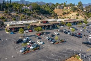
    Perhaps the most obvious use of drones in land development is to capture aerial imagery. Drones equipped with high-resolution cameras can capture detailed images of the land, including topography, vegetation, and existing infrastructure. Drone service providers use this information to create detailed 3D maps and models that can be used to inform design decisions.

    Thermal Imagery

    Drones can also be equipped with thermal cameras, which can detect heat signatures. This can be useful for land development projects where heat signatures can indicate potential problems, such as leaking pipes or hotspots in electrical systems. Thermal imagery can also be used to detect changes in temperature that may indicate changes in land use, such as the construction of new buildings or roads.

    LiDAR

    Drones can be equipped with LiDAR (Light Detection and Ranging) sensors, which use lasers to create high-resolution maps of the land. This technology is particularly useful for land development projects that involve complex terrain or structures, such as bridges or tunnels. LiDAR can also be used to detect changes in elevation, which is important for projects that involve grading or excavation.

    Environmental Data

    Drones can be used to capture a wide variety of environmental data for land development projects, including air and water quality, noise levels, and wildlife populations. This information can be used to identify potential environmental impacts of the project and develop mitigation strategies.

    Image of Glendale Sudios Orthomosaic X
    Construction progress monitoring includes orthomosaic images

    Construction Monitoring

    Aerial Decisions uses drones to monitor construction progress and detect any potential issues that are time sensitive in nature. By capturing high-resolution images and videos of the construction site, we assist developers in identifying potential problems early on and make any necessary adjustments to the project.  Additionally, drones can also be used to inspect properties and land without the need for workers to access potentially hazardous areas.  This can help to improve safety on job sites and reduce the risk of accidents.  Another useful drone application is in the area of on site supply management.  Drones can capture volume data for project stockpiles and immediately transfer that data to supply chain managers, ensuring the timely delivery of fresh supplies to each job site.

    In conclusion, I can say definitively that drones have become a valuable tool for commercial land development projects. They are capable of capturing a wide variety of data, including aerial and thermal imagery, LiDAR data, environmental data, and construction monitoring data. By using drones to collect this information, developers can make more informed decisions and improve project outcomes.

    From The Editor:

    Do you need to hire a professional drone service provider?  To speak to an aerial data specialist, fill out a form, email us or for even faster response times, give us a call at (833) FLY-4YOU or (833) 359-4968.  Check out our transparent pricing at Drone Photography Pricing and watch this space as we expand on the above topics and more over the coming weeks and months.  If you like this post, feel free to click the share button at the bottom of the page.  We appreciate you helping us by spreading the content we share on our blog.

  • 5 Benefits of Using Drones in Commercial Real Estate

    5 Benefits of Using Drones in Commercial Real Estate

    The adoption of aerial drone photography in the commercial real estate industry is on the rise. Like other industries, there are many benefits of using drones for commercial real estate, including improved efficiency, cost savings, and higher quality data. In this blog post, I will discuss the top five benefits of using drones in commercial real estate, along with recent statistics illustrating the uptick of drone adoption in the industry; specifically in the Los Angeles market.

    Image of Indian Springs Cre For Lease X
    Los Angeles Commercial Retail Center

    Here we go: 

    Faster and More Efficient Surveys

    Drones are able to capture high-resolution aerial imagery of properties and land. This means that surveys can be conducted faster and more efficiently, saving time and reducing costs. In fact, a recent survey found that 90% of commercial real estate professionals believe that drones have improved the speed and efficiency of their work.

    Improved Marketing

    Drones can capture stunning aerial footage of properties that can be used in marketing materials. This can help to attract potential buyers or tenants, as well as showcase a property’s unique features. According to a recent report, using drones in real estate marketing can lead to a 68% increase in listing views.

    Image of Dji X
    Commercial Real Estate Rooftop Drone Inspection

    Enhanced Property Inspections

    Drones can perform inspections of roofs, facades, and other hard-to-reach areas of a commercial real estate property. This can help to identify potential issues before they become major problems, leading to cost savings and improved safety.

    More Accurate Property Valuations

    Drones can capture high-quality aerial imagery that can be used to create accurate 3D models of commercial properties. This can help to provide a more accurate valuation of a property, leading to better informed decisions and potentially higher profits.

    Increased Safety

    Drones can be used to inspect properties and land without the need for workers to access potentially hazardous areas. This can help to improve safety on job sites and reduce the risk of accidents.

    Now, let’s take a look at some recent statistics on drone adoption in the commercial real estate industry. According to a recent report, the use of drones in commercial real estate has increased by 200% in the last year alone. Additionally, the Los Angeles commercial real estate market has been identified as having significant potential for the use of drones in real estate. With the city’s large and diverse real estate market, drones can be used to capture aerial footage of a wide range of properties, from industrial warehouses to luxury residential homes.

    In conclusion, I believe the benefits of using drones in commercial real estate are numerous. From improved efficiency and cost savings to higher quality data and increased safety, drones are helping to revolutionize the way that real estate professionals conduct their work. As adoption rates continue to grow, I fully expect to see even more innovative uses of drones in the commercial real estate industry.

    From The Editor:

    Do you need to hire a professional drone service provider?  To speak to an aerial data specialist, fill out a form, email us or for even faster response times, give us a call at (833) FLY-4YOU or (833) 359-4968.  Check out our transparent pricing at Drone Photography Pricing and watch this space as we expand on the above topics and more over the coming weeks and months.  If you like this post, feel free to click the share button at the bottom of the page.  We appreciate you helping us by spreading the content we share on our blog.