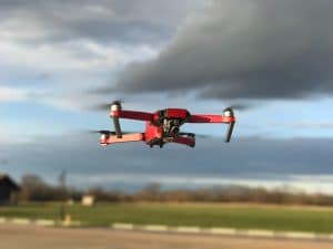
The adoption of aerial drone photography in the commercial real estate industry is on the rise. Like other industries, there are many benefits of using drones for commercial real estate, including improved efficiency, cost savings, and higher quality data. In this blog post, I will discuss the top five benefits of using drones in commercial real estate, along with recent statistics illustrating the uptick of drone adoption in the industry; specifically in the Los Angeles market.
Los Angeles Commercial Retail Center
Here we go:
Faster and More Efficient Surveys
Drones are able to capture high-resolution aerial imagery of properties and land. This means that surveys can be conducted faster and more efficiently, saving time and reducing costs. In fact, a recent survey found that 90% of commercial real estate professionals believe that drones have improved the speed and efficiency of their work.
Improved Marketing
Drones can capture stunning aerial footage of properties that can be used in marketing materials. This can help to attract potential buyers or tenants, as well as showcase a property’s unique features. According to a recent report, using drones in real estate marketing can lead to a 68% increase in listing views.
Commercial Real Estate Rooftop Drone Inspection
Enhanced Property Inspections
Drones can perform inspections of roofs, facades, and other hard-to-reach areas of a commercial real estate property. This can help to identify potential issues before they become major problems, leading to cost savings and improved safety.
More Accurate Property Valuations
Drones can capture high-quality aerial imagery that can be used to create accurate 3D models of commercial properties. This can help to provide a more accurate valuation of a property, leading to better informed decisions and potentially higher profits.
Increased Safety
Drones can be used to inspect properties and land without the need for workers to access potentially hazardous areas. This can help to improve safety on job sites and reduce the risk of accidents.
Now, let’s take a look at some recent statistics on drone adoption in the commercial real estate industry. According to a recent report, the use of drones in commercial real estate has increased by 200% in the last year alone. Additionally, the Los Angeles commercial real estate market has been identified as having significant potential for the use of drones in real estate. With the city’s large and diverse real estate market, drones can be used to capture aerial footage of a wide range of properties, from industrial warehouses to luxury residential homes.
In conclusion, I believe the benefits of using drones in commercial real estate are numerous. From improved efficiency and cost savings to higher quality data and increased safety, drones are helping to revolutionize the way that real estate professionals conduct their work. As adoption rates continue to grow, I fully expect to see even more innovative uses of drones in the commercial real estate industry.
From The Editor:
Do you need to hire a professional drone service provider?To speak to an aerial data specialist, fill out a form, email us or for even faster response times, give us a call at (833) FLY-4YOU or (833) 359-4968.Check out our transparent pricing at Drone Photography Pricing and watch this space as we expand on the above topics and more over the coming weeks and months. If you like this post, feel free to click the share button at the bottom of the page. We appreciate you helping us by spreading the content we share on our blog.
As long as I’ve been in the drone tech industry, the most common discussion of where the biggest growth sector in drone applications has been in the construction space. Most consider top of mind commercial, industrial and even residential construction. But if you dig a little deeper, you’ll see that an often overlooked sector of the construction industry lies at the heart of the most significant growth area in the near term; construction and infrastructure projects.
Why is that?
The recent Infrastructure Investment and Jobs Act, signed into law in November 2021, includes $1.2 trillion in funding for critical infrastructure projects over the next decade.
This funding is expected to accelerate the adoption of drone technology in state government infrastructure programs. According to a recent report by Drone Industry Insights, the global infrastructure inspection market is projected to grow at a CAGR of 21.5% from 2020 to 2027. In recent years, drone technology has seen rapid development and widespread adoption in many industries.
State government infrastructure programs are at the top of that list. Drones offer unique capabilities that can help with planning, design, and maintenance of critical infrastructure projects.
In this blog post, I will share 4 key reasons for using drone technology to aid state government infrastructure programs and how the recent Infrastructure Investment and Jobs Act and federal funding is impacting the progress of critical infrastructure programs.
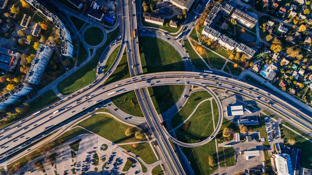
drone monitoring for road infrastructure projects
Surveying and Mapping
Drones can quickly and accurately survey and map large areas of land, including difficult-to-reach areas such as mountainous terrain, forests, and wetlands. This technology can be used to gather data for various infrastructure projects, such as highways, bridges, and pipelines. According to a recent study by ResearchAndMarkets, the global drone surveying market is projected to grow at a CAGR of 35.2% from 2021 to 2026.
drone monitoring for infrastructure projects
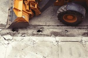
Construction Monitoring
Drones can be used to monitor construction sites, track progress, and detect potential safety hazards. This technology can help improve construction efficiency, reduce costs, and increase safety. According to a recent report by DroneDeploy, drone use in construction increased by 239% in 2020 compared to the previous year.
Bridge infrastructure construction inspections with drones
Inspections
Drones can perform inspections of critical infrastructure, such as bridges, dams, and power lines, without the need for costly and dangerous manual inspections. This technology can help identify potential safety issues before they become critical and prevent downtime due to unexpected failures. According to a recent report by Markets and Markets, the global drone inspection market is projected to grow at a CAGR of 23.6% from 2021 to 2026.
Environmental Monitoring
Drones can be used to monitor environmental conditions, such as water quality and air pollution, in remote areas. This technology can help government agencies identify and mitigate environmental risks, such as oil spills and chemical leaks. According to a recent report by MarketsandMarkets, the global drone environmental monitoring market is projected to grow at a CAGR of 11.4% from 2021 to 2026.
In conclusion, drone technology has significant potential to aid state government infrastructure programs. From surveying and mapping to construction progress monitoring, drones can help government agencies improve efficiency, reduce costs, increase safety, and mitigate environmental risks. As I mentioned above, the recent Infrastructure Investment and Jobs Act and federal funding are expected to drive growth in this market sector, which is projected to grow at a significant rate over the next decade.
From The Editor:
Do you need to hire a professional drone service provider?To speak to an aerial data specialist, fill out a form, email us or for even faster response times, give us a call at (833) FLY-4YOU or (833) 359-4968.Check out our transparent pricing at Drone Photography Pricing and watch this space as we expand on the above topics and more over the coming weeks and months. If you like this post, feel free to click the share button at the bottom of the page. We appreciate you helping us by spreading the content we share on our blog.
Drones are quickly becoming a staple in the construction industry. They are increasingly being used for a wide range of tasks, including surveying, mapping, and progress monitoring. And the key statistics show that drone adoption in construction is on the rise. Let’s take a closer look at the statistics.
Drones in Construction
According to various market reports and studies, the use of drones in the construction industry is on the rise and is expected to continue growing in the coming years. Here are some key market statistics on the use of drones in construction:
Market size: The global construction drone market size was valued at $1.12 billion in 2020 and is expected to reach $2.82 billion by 2026, growing at a compound annual growth rate of 17.1% during the forecast period.
Increased adoption: The adoption of drones in the construction industry has increased significantly in recent years. In 2020, more than 50% of construction companies in the US were reported to be using drones for construction project monitoring.
Time and cost savings: The use of drones in construction has been shown to save time and reduce costs. For example, construction companies that use drones for progress monitoring have reported a reduction in project time by up to 20%.
Improved safety: The use of drones has improved safety on construction sites by reducing the need for workers to access hazardous areas or perform dangerous tasks.
High-quality data: Drones are equipped with high-quality cameras and sensors that provide detailed images and data of construction sites. This data can be used to make informed decisions and improve the accuracy of construction projects.
Overall, the use of drones in the construction industry is growing rapidly and is providing significant benefits to construction companies in terms of time and cost savings, improved safety, and high-quality data. Statistics show the expectation is the use of drones in construction will continue to grow as technology advances and construction companies continue to realize the benefits of this innovative technology. If your company is looking to leverage the latest drone technology to get your projects completed on time and within budget, call us for a free consultation today.
From The Editor:
Do you need to hire a professional drone service provider?To speak to an aerial data specialist, fill out a form, email us or for even faster response times, give us a call at (833) FLY-4YOU or (833) 359-4968.Check out our transparent pricing at Drone Photography Pricing and watch this space as we expand on the above topics and more over the coming weeks and months. If you like this post, feel free to click the share button at the bottom of the page. We appreciate you helping us by spreading the content we share on our blog.
As construction executives, it’s important to stay ahead of the curve and utilize new technologies that can save time and money on construction projects. One such technology is the use of drones to monitor construction progress.
Construction Crew Site Walk-Through
In the past, construction managers would have to physically visit a construction site to inspect the progress and take photos or videos. This process was not only time-consuming but also expensive, as it required transportation costs and the cost of having someone present at the site.
A recent study found that drone usage has been steadily on the rise. Currently, drones are being utilized on 55% of projects, up from 48% in 2021 and 36% in 2022. According to Dodge, usage is higher among large contractors (67%) compared with small contractors (9%).
By using drones, construction managers can now remotely monitor construction sites in real-time and receive high-quality photos and videos of the progress. This has several benefits, including the following:
Increased Efficiency: Drones can cover a large area in a short amount of time, providing construction managers with a quick and efficient way to monitor progress. This saves time and allows construction managers to focus on other important tasks.
Reduced Labor Costs: With drones, there’s no need to have someone physically present at the site to inspect the progress. This reduces labor costs and makes the process more cost-effective.
Improved Safety: Drones can be flown over hazardous areas, reducing the risk of injury to construction workers. They can also be used to inspect tall structures, reducing the need for workers to climb up and inspect them.
Increased Accuracy: Drones are equipped with high-quality cameras and can provide detailed images and videos of the construction site. This allows construction managers to identify any issues and make necessary changes in real-time, resulting in more accurate and efficient construction.
Time Savings: With the ability to remotely monitor construction sites, construction managers can save time by not having to physically visit the site. They can also quickly receive and review progress reports, allowing them to make informed decisions and keep the project on track.
In conclusion, the construction revolution is in full swing and the impact of drones on project monitoring and management is un-mistakable. It’s clear, using drones to monitor construction progress is a cost-effective and efficient solution that can help construction executives save time and money. With the ability to remotely monitor construction sites, reduce labor costs, improve safety, increase accuracy, and save time, it’s clear that drones are a valuable tool for the construction industry.
From The Editor:
Do you need to hire a professional drone service provider?To speak to an aerial data specialist, fill out a form, email us or for even faster response times, give us a call at (833) FLY-4YOU or (833) 359-4968.Check out our transparent pricing at Drone Photography Pricing and watch this space as we expand on the above topics and more over the coming weeks and months. If you like this post, feel free to click the share button at the bottom of the page. We appreciate you helping us by spreading the content we share on our blog.
The construction industry involves the building, maintenance, and improvement of infrastructure and buildings. This includes a wide range of activities, such as residential and commercial construction, road and bridge building, and utility work.
There are several challenges that the construction industry faces, including:
Cost and budget management: Construction projects often have strict budgets and timelines, and any delays or cost overruns can have significant financial implications.
Safety: The construction industry has a high rate of workplace injuries and fatalities. Ensuring the safety of workers is a top priority.
Productivity: Construction projects can be complex, with many different stakeholders and variables involved. Maintaining productivity and efficiency is crucial to ensure that projects are completed on time and within budget.
Several other challenges, including, skilled labor shortages, environmental concerns and the rapid technological advancements are prominent but in this post, I want to focus on how drone technology can help the top 3 on the above list.
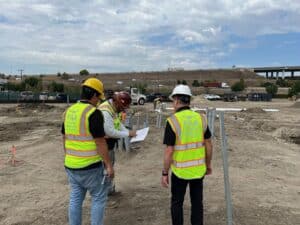
Drone pilot working with site GM to solve construction project challenges.
Here are my Top 5 ways drone technology can solve challenges the construction industry faces today:
Construction Monitoring
Drones provide a cost-effective way to manage critical functions for Contractors and Construction Firms. Drones can produce high-resolution, on-demand, aerial photography of important project elements such as monitoring subcontractors, stockpile management, materials, equipment, and site security.
Construction Surveying
The use of drones in construction surveying has become commonplace in today’s building landscape. Where older surveying technologies fell short in terms of production turn-around, cost, and accuracy, photogrammetry has been a game-changer in each of these areas.
Construction Progress Reporting
Key stakeholders (i.e.., Investors) can be visually connected to project progress in new and innovative ways. The programmatic use of drones to produce high-quality aerial images and video enables near real-time inspection of all aspects of the project. Images can be easily rendered in 3D models, orthomosaic maps, and other photogrammetry data to monitor site progress.
Construction Inventory Management
One of the most basic functions for a contractor is inventory management. Aerial photography of a job site provides actionable data for contractors to assess and respond to critical inventory needs. Drones transform the risky, labor-intensive and time-consuming job of manual inventory counts and volumetric assessments into timely and cost-effective tasks.
Construction Structural Site Integrity
Assessing structural vulnerabilities is a key job function of the project General Contractor. Key stakeholders are acutely attuned to the notion of minimizing the risk associated with potential structural defects. The use of drones to identify such defects helps to mitigate potential lawsuits and other aspects that could create costly delays in project completion.
It’s clear drones have the potential to solve several construction industry challenges and make project deliverables more efficient, safe, and cost-effective.
From The Editor:
Do you need to hire a professional drone service provider?To speak to an aerial data specialist, fill out a form, email us or for even faster response times, give us a call at (833) FLY-4YOU or (833) 359-4968.Check out our transparent pricing at Drone Photography Pricing and watch this space as we expand on the above topics and more over the coming weeks and months. If you like this post, feel free to click the share button at the bottom of the page. We appreciate you helping us by spreading the content we share on our blog.
Most people are well aware that drones have cameras and can take photos and videos while in flight.But few outside the industry realize just how useful those pictures and videos can be for a variety of business, real estate, agriculture, construction, insurance and more.
Drones are capable of highly technical data collection using a variety of on-board technology, sophisticated cameras and 3rd party software.From inspections and infrastructure management to surveying and mapping, we have only just begun to realize the full potential for drone technology to deliver value for industries of all types.
If you’re new to the drone industry it can sometimes feel daunting to keep up with the technology and the myriad of commercial applications that drones can handle.One of the more common uses of drones for industry involves the use of photogrammetry.
What is Photogrammetry?
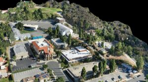
Photogrammetry involves taking multiple pictures of an object, for example aerial photographs of an empty parcel of land, and assembling them into complex 2D or 3D models.
Glendale Adventist 3D Map
These models can be used by industries ranging from construction, real estate, agriculture and more to understand and evaluate development requirements; oftentimes much faster and with less cost than conventional methods.
Once assembled into the the final image, the individual images are stitched together to form a new, sharper image called an Orthomosaic.
Google Maps ImageOrthorectified Image
What is an Orthomosaic?
Orthorectified Image
An orthomosaic is a large, map quality, image made by stitching together a significant number of smaller, individual images (called orthophotos) into one high resolution image.
Orthoimages are aerial photos that are corrected for:
Lens Distortion
Camera Tilt
Perspective
Topographic Relief (adjusted for the curvature of the earth’s surface)
These Orthoimages have no distortion and are uniformly scaled across the image.The main difference between a typical aerial photo and an orthophoto is:
The aerial photo shows the effects of the natural curvature of the earths surface (showing, for example, the sides of buildings from a top down perspective) while the orthophoto is geometrically corrected.This orthorectified image presents a geometrically accurate top down view of objects on the ground.
How are Othomosaics Being Used?
When integrated into sophisticated software (like Drone Deploy), Orthomosaics are used to get the most up to date aerial view of an object on the earth’s surface; for example, a parcel of land or new construction project.Real estate professionals consider orthomosaics to be the best way to get an up to date and accurate aerial photo of a large parcel of land.Construction firms look to this type of aerial image as a way to get accurate measurements of a project as well as regular updates on the progress of each construction site.Agriculture can use orthorectified images to inspect crops and determine plant health. Drones can also produce images that, when converted into orthomosaics, can be used to aid in inspecting rooftops, buildings, solar panels, bridges, pipelines and cell towers.
And the list goes on.
Why Are Orthomosaics Important?
In short, orthoimages can be used to help streamline processes, create massive efficiencies of scale and help industries save valuable time and money. Whether you need aerial photography services for construction, real estate, land development or inspections, Aerial Decisions can handle all of your photogrammetry needs.
From The Editor:
Do you need to hire a professional drone service provider?To speak to an aerial data specialist, fill out a form, email us or for even faster response times, give us a call at (833) FLY-4YOU or (833) 359-4968.Check out our transparent pricing at Drone Photography Pricing and watch this space as we expand on the above topics and more over the coming weeks and months. If you like this post, feel free to click the share button at the bottom of the page. We appreciate you helping us by spreading the content we share on our blog.
When it comes to marketing commercial real estate properties and land parcels, drones are powerful photography tools, offering a cost-effective and time-saving solution to capture aerial imagery for broker listings. So, what do real estate agents look for when hiring a commercial drone service provider? Here are our top five tips for shooting commercial real estate to capture a birds-eye view of expansive properties.
1) Start With the Basics
Understand State and Local Laws
As a Part 107 Remote Drone Pilot, you already know the ins and outs of FAA restricted airspace. But some states and/or cities may also prohibit aerial photography in areas like public parks. Additionally, many municipalities prohibit flights over private property without the express permission of the property owner. Avoid conflict by checking for local laws that may affect your specific mission.
Learn the Industry Jargon
You will be much better positioned to market your drone services if you take time to learn the jargon, understand the challenges that commercial real estate brokers are facing and develop a feel for what your Clients need.
Here are some basic terms that can help you understand commercial real estate industry jargon:
Anchor Tenant: A core tenant – typically a major retail chain with prestige and popularity to attract other retail tenants and consumers.
Pad Site: A pad site, or outparcel, is a freestanding parcel of commercial real estate located in front of a larger shopping center or strip mall. Common occupants of pad sites include banks and restaurants.
Offering Memorandum (OM): A presentation and legal document that summarizes an offering for potential investors.
Net Lease: By signing a net lease, the tenant agrees to pay one or more of the three major expense categories: taxes, maintenance, and insurance fees. Net leases are defined as follows:
Single (net): Tenant pays one of the three expense categories
Double (net-net): Tenant pays two of the three expense categories
Triple (net-net-net): Tenant pays all three expense categories.
Mixed Use: A mixed use development is a property that can be occupied by various categories of tenants, which may include combined zoning for retail, residential, office, and/or industrial. A common form of a mixed-use property in urban areas features ground-level retail with apartments or office space above.
Deferred Maintenance: The practice of deferring needed maintenance or repairs on a property (e.g., potholes, broken gutters, crumbling sidewalks, missing roof shingles, peeling paint, etc.). Investors evaluating the purchase of a property must consider the negative impact of deferred maintenance on future cash flow.
2) Check the Map and Use a GPS Device
Vacant lots in rural areas do not always have a street address. In fact, the broker may just give you cross streets and a brief description of the property. Additionally, cell service may not be available in rural areas surrounding vacant land. As such, if you are shooting a vacant lot or working with a land development company, be sure to get exact GPS coordinates of the property, download and print driving directions before leaving, and bring a GPS device to make sure you are shooting the correct area.
3) Show Off the Value of the Property
Stage the Property
Your Client (the listing broker or real estate agent) should handle this in advance of your mission. Staging may include sprucing up building facades, paint, landscaping, signage, etc. The better your subject looks, the easier it is to get good photos and videos to help your Client market the property.
Highlight the Best Features
In addition to highlighting the property itself, be sure to get wide-angle shots that include any nearby mountains, streams, lakes, forest, scenic views, or other features in the frame. The goal here is to “show off” the best features of the property, along with proximity to roadways, highways, other retail space, shopping centers, land parcels and population centers. And, lastly, for restaurants and retail establishments, shoot at a busy time of day to show a full parking lot and a high level of traffic flow in the area.
4) Capture Good Lighting with a Variety of Shots and Angles
Shoot Between About 10:00 a.m. and 2:00 p.m.
Mid-day is the best time to take both top-down (Nadir) shots and oblique shots as the position of the sun directly overhead minimizes shadows. Shooting earlier or later in the day will result in longer shadows, making it difficult to show the property in its best light.
Use a solar app in advance to check for the best time to shoot, and ensure the front façade of the property will not be lost in shadows when you are shooting:
Just because you are shooting with a drone, don’t think you have to shoot everything from directly overhead. Shooting a greater quantity and wider variety of shots from multiple altitudes and angles will provide your Client (the real estate broker or agent) with more ways to capture their prospective client’s attention by envisioning their restaurant, store, warehouse, office building or other commercial property in that location.
Lastly, be sure to capture more than one shot of each image. Taking multiple shots reduces the possibility of having your photo spoiled by a gust of wind, lens flare reflected from a nearby window, etc.
Key Photos to Shoot
Nadir Photos Looking straight down – no horizon
Always Consider Access to Major Freeways
Property only – Get high enoughto capture the entire building or lot in the frame.
Property + Surrounding area – Get even higher and include any nearby mountains, streams, lakes, forest, scenic views or other features in the frame.
Property + Ingress/Egress – Get high enough and adjust composition to show proximity to roadways, highways, other retail space, shopping centers, land parcels and population centers.
Oblique Shots Looking down at an angle – with horizon – shoot from three different altitudes
Example of Oblique Shot of Commercial Real Estate
Note: Oblique shots should always include the horizon in the top 15% to 25% of the frame.
Oblique Elevations (shoot from three different altitudes)
Note: Altitudes vary, depending on population density. For sparsely populated areas, shoot from a higher altitude to capture more of the surrounding area.
Oblique Shots from Corners and Sides – with horizon – shoot looking down at an angle from:
Each side (all major building facades – front, sides and back)
All four corners of the building
All cardinal compass points (N, E, S, W), and points in between
Include shots that feature signage in foreground and property in background
Show proximity to roadways and highways to indicate points of ingress/egress
Wherever possible, include surrounding properties in frame
Show proximity to other land parcels, shopping centers, and population centers
Make every effort to include features that may attract clientele for a potential buyer or tenant.
Is the property in a strip mall, next to a major hotel or retail chain? Include it! e.g., if you are shooting a grocery store that is adjacent to a major hardware store, be sure to get photos that depict both stores to provide context for the prospective client.
For restaurant or retail space, shoot at a time of peak usage – when the parking lot is full (you want to show a busy property!)
Detail Photos
In addition to shooting the property’s best shots and angles, be sure to capture aerial photos of any “less desirable” features such as trash enclosures, structures or vehicles abandoned on the property, nearby industrial activity such as an oil well or quarry, etc. Shoot these separately and leave it to the broker’s discretion as to what he or she wishes to use for marketing or disclosure purposes.
Use Intuitive and Consistent Photo File Naming Conventions Name each photo file with the shot type, corresponding features and/or compass points, e.g.,
Aerial_Nadir_Full_Lot.jpg
Aerial_Looking_North.jpg
Aerial_Looking_NE.jpg
Aerial_NW_Corner_Looking_South.jpg
. . .
Key Video Footage to Shoot
When shooting video, as with stills, be sure to show off the property’s best features. Here is a list of key footage to shoot:
Dolly Shots
Dolly shots of the façade(s) Facing front of building– move slowly from left to right and right to left from various distances and elevations. Start dolly movement before one side of property and end past other side.
Panos (left to right and right to left) Drone stays stationary at horizontal centerline of building while camera pans (rotates) from side to side.
Flyovers
Flyovers – Close (8 passes) Keep horizon in top 15% of frame.
Flyovers from front to back and back to front (2 passes)
Flyovers from side to side (2 passes – left to right and right to left)
Flyovers from corner to corner in all directions (4 passes)
Flyover – Distant Keep horizon in top 15% of frame.
Flyover to feature adjacent properties, proximity to points of ingress/egress, signage, and full parking lot.
Orbits
360 Degree Orbit with Horizon Include surrounding roads and highways, buildings, topographic features and/or other areas of interest with horizon visible in top 15% of frame.
Note: Taller buildings may require a second orbit to feature signage.
360 Degree Orbit Without Horizon Oblique angle featuring property and surrounding streets only – no horizon.
Fade-Away
Fade-Away (“Dronie”) Start close to property. Fly up and back while keeping camera focused on property with horizon in top 15% of frame.
Use Intuitive and Consistent Video File Naming Conventions Name each video file with the shot type, corresponding features and/or compass points, e.g.,
Flyover_North-South.mov
Flyover_Corners_1.mov
Pano_1.mov
Full_360_Orbit_1.mov
. . .
Detail Video Footage
Roof and HVAC Flyover
Low, slow pass over roof with camera in Nadir position (straight down) to see details – may require multiple passes to cover entire roof.
Parking Lot Flyover
Low, slow pass over parking lot with camera in Nadir position (straight down) to see details – may require multiple passes to cover entire parking lot.
Trash Enclosure Flyover
Low, slow pass over trash enclosure(s) with camera at oblique angle to see details – may require multiple passes if more than one trash enclosure.
Signage Flyover
Slow pass starting at ground and going up one side of the entire sign, over, and down the other side of the sign. May require multiple passes if more than one sign.
5) Shoot Everything in RAW
Why shoot RAW versus JPEG? Simply stated, RAW gives you the highest level of quality and records a greater range of brightness.
All cameras technically shoot RAW, meaning that every time you snap the shutter you are capturing all the RAW data directly from the sensor. However, the data compression that occurs during the JPEG conversion process discards some of the RAW data, significantly reducing image quality. JPEG compression severely limits flexibility in post-production to correct things like exposure and color temperature. When you shoot RAW, you skip the JPEG compression and conversion process and capture all the data straight from the sensor. This allows you to do the processing and make key decisions on the appearance of the image to produce much better results in post-production.
Think of RAW versus JPEG like high-definition versus standard-definition television in terms of the quality and depth of color it provides.
Final Thoughts
Aerial drone photography for commercial real estate may sound like a simple thing, but it’s easier said than done. Before shooting your first real gig, find a nearby strip mall, warehouse or piece of vacant land, then get out there and practice until you’ve mastered the list of photo and video shots above. Put together a killer portfolio and a demo reel, then get out there and make some money!
From The Editor:
Do you need to hire a professional drone service provider?To speak to an aerial data specialist, fill out a form, email us or for even faster response times, give us a call at (833) FLY-4YOU or (833) 359-4968.Check out our transparent pricing at Drone Photography Pricing and watch this space as we expand on the above topics and more over the coming weeks and months. If you like this post, feel free to click the share button at the bottom of the page. We appreciate you helping us by spreading the content we share on our blog.
So you’ve just passed your FAA Part 107, purchased your new DJI Mavic Pro 3 Fly More Combo and you are ready to start earning money as a drone service company. Slow your roll for a second and let’s first establish some priorities.
The Tools of the Photography Portfolio
One of the first things any photographer does before launching their professional career is to create a portfolio that includes examples of their own creative work. Whether packaged in a physical artwork folder or digitally maintained online, the professional photographers portfolio is their professional calling card and an absolute necessity.
Although, as aerial photographers, we refer to our work samples as a “reel”, the same thing applies to us as well.
As a fledgling drone service company, it’s important not to underestimate the importance of having quality footage to show a prospective client. In fact it’s the first question every client prospect asks us before agreeing to meet with one of our crew in our drone pilot network. Without one, it’s a conversation non-starter.
The reel or your first gig, which comes first?
The biggest question we hear from many a new pilot is, “if I haven’t done any professional work, what do I use for my reel?”. Much like the proverbial chicken and egg metaphor, many new to our industry don’t know where to start.
If you are asking the same question, then this blog post is for you.
Absent having many (if any) paid professional gigs to count on for work samples, drone pilots need to get creative.
Here are top-five tips to source great drone footage for what may be your very first professional reel:
Shoot Aerial Footage of Your Home: your own home is a perfect place to start, especially if you are looking to start your career in aerial photography for real estate. There’s no one to ask permission and as long as you are clear to fly in your area, there’s no better place to grab your first residential footage.
Ask a Neighbor Who’s Selling Their Home: See a “for sale” sign in your neighborhood? Ask your neighbor if they’d allow you to shoot some aerial footage of their home and that you’ll give them a copy of the footage (for free!). They may already have an agent who has provided them aerial footage of their home but it never hurts to have additional shots they can share with family and friends on their own social network. Tell them you are just getting started with your new business and many people will be happy to help. And, remember to share your shots on your own social media with a link to their online listing.
Ask a Real Estate Friend for Help: Your real estate friend is likely already using a drone photographer through their brokerage firm. Your intention (at least initially) is not to replace their current provider but to ask to practice on a home they may be listing. Again, promise to give them a copy of the footage you shoot and let them know you will give them attribution when you post your shots to your own social media account. For them, the additional footage and free publicity alone is worth the price of admission. By the way, we’ve heard countless stories of drone pilots who’ve started this way and ended up winning the agent as a regular client (or better yet, win a new client via a referral).
Head to a Local Strip Mall: Want to start working in commercial real estate? There’s no better place to start than shooting aerial footage of your local retail center. One thing to note about shooting commercial real estate is that it requires some additional knowledge and specialized skills. We recommend doing some research on the topic prior to heading out. Also, look for a future post on this topic as we dive deeper into aerial photography for commercial real estate.
Enroll in a Community College Drone Pilot Training Program: Aerial photography classes are fast becoming a staple at local community colleges and many new pilots have obtained extensive material in the course of earning their certificates. We work with several in our neck of the woods including Grossmont College’s Drone Technology Program led by UAS industry veteran, Skip Fredricks.
The key takeaway I hope everyone leaves with is your reel is the most important and first thing you should consider working on after obtaining your Part 107 license. Doing so will help you to avoid significant frustration and help you to overcome many of the challenges that drive newer pilots from continuing to pursue a professional career in drone photography.
If you feel I have missed an important one, hit us up on Social Media and let us know what you think (Twitter, Facebook, Instagram).
From The Editor:
Do you need to hire a professional drone service provider?To speak to an aerial data specialist, fill out a form, email us or for even faster response times, give us a call at (833) FLY-4YOU or (833) 359-4968.Check out our transparent pricing at Drone Photography Pricing and watch this space as we expand on the above topics and more over the coming weeks and months. If you like this post, feel free to click the share button at the bottom of the page. We appreciate you helping us by spreading the content we share on our blog.
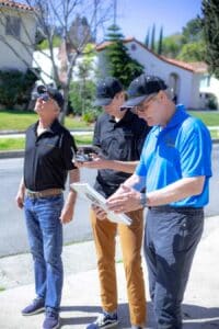
The primary role in every aerial photography mission is owned by the drone pilot-in-charge (PIC), however, the unsung hero of the drone flight crew is the visual observer.Although the drone pilot must always maintain the capability to see the drone in flight, utilizing one or more visual observers allows the pilot to conduct other mission-critical duties while still ensuring situational awareness of the drone.
What, exactly, does the visual observer do?The role of the visual observer is that he or she maintains constant visual contact with the drone, scans for other aircraft and hazards in the area, and communicates to the pilot any instructions required to keep him or her advised on the Drone’s status during flight operations.
Why should any of this matter to real estate agents?
Here are 5 key benefits of having a visual observer on every aerial photo shoot:
Visual Observer Assisting Pilot and Drone Operator
1. Mitigate Risk
Before and during each mission, drone pilots have a tremendous amount on their plate.A visual observer helps to keep the pilot focused on the safe outcome of each mission.
2. Higher Quality Production
An experienced visual observer can also be helpful in setting up important shots by directing the best position and angle for the pilot to photograph the target.
3. Pilot Redundancy
There’s nothing more disappointing than discovering the primary pilot is unable to participate in the mission due to a last-minute emergency.When this happens, a visual observer, who also happens to be Part 107 Certified, can act as a back-up to the primary pilot.Since we feel “the show must go on”, Aerial Decisions always strives to staff each aerial photography mission with this type of redundancy.
4. Scene Management
In the case of smaller productions, the visual observer may also serve as the scene manager, fielding questions from bystanders and dealing with any issues that may negatively impact the pilot’s ability to focus their attention to the safety and control of the aircraft.This is one less thing the real estate agents needs to worry about.
5. Safety
A visual observer keeps the pilot advised on the drone’s location, attitude, altitude, and direction of flight.He or she also notifies the pilot of the position of other aircraft or hazards in the immediate airspace.Finally, the visual observer ensures that the drone does not endanger the life or property of another.
Despite the fact the use of a visual observer is optional when operating under FAA Part 107 rules, they should always be considered an integral part of any aerial photography project.
From The Editor:
Do you need to hire a professional drone service provider?To speak to an aerial data specialist, fill out a form, email us or for even faster response times, give us a call at (833) FLY-4YOU or (833) 359-4968.Check out our transparent pricing at Drone Photography Pricing and watch this space as we expand on the above topics and more over the coming weeks and months. If you like this post, feel free to click the share button at the bottom of the page. We appreciate you helping us by spreading the content we share on our blog.
The Federal Aviation Administration (FAA) regulates all airspace in the United States and has specific statutory rules for unmanned aircraft systems, including the need to register drones. At the time of this writing, there were 347,957 commercial drones registered in the US. So why should commercial drone pilots register their drones?
Register Your Drone at www.faadronezone.faa.gov
1. It helps ensure the safety of our national airspace
The FAA created the National Airspace System (NAS) to protect people and property on the ground, and to establish a safe and efficient airspace environment for civil, commercial, and military aviation.
Drones are fundamentally changing aviation, and the FAA is working to fully integrate drones into the NAS. FAA Part 107 is the set of FAA regulations that describe how, when, and where drones may be flown for commercial purposes. By flying registered drones under Part 107 rules, commercial drone pilots are helping to keep people, property, their drone, and our National Airspace safe.
2. The FAA will soon require Remote ID (RID) to track the use of drones
As part of a new Unmanned aircraft Traffic Management (UTM) system, the FAA recently announced the Remote Identification (RID) rule for drone pilots. Under this new rule, all drone operators are required to equip their drones with RID technology no later than September 16, 2023.
Remote ID will broadcast a unique identifier that is tied to the drone’s registration, allowing the FAA, law enforcement, and other federal agencies to log flight paths, track drone operations, and locate the control station when a drone appears to be flying in an unsafe manner or in an area where it is not allowed to fly. This technology also lays a foundation for the safety and security groundwork needed for more complex drone operations utilizing UTM in the future.
FAA Remote Pilot Seal
3. A unique FAA registration number must be displayed on all commercial drones
Per FAA Part 107 regulations, all drones weighing less than 55 pounds that are flown commercially must be labeled with a unique registration number that is clearly visible on the outside of the drone.
4. It only costs $5 and takes about 10 minutes to register a drone for commercial use
Commercial drone operators must register each of their drones individually with the FAA Drone Zone. The good news is that this can be done online, and only costs $5 per drone.
5. Pilots who fly an unregistered drone for commercial purposes may face steep penalties
Registering a drone at the FAA Drone Zone website is a statutory requirement. Failure to register a drone may result in both civil and criminal penalties. The FAA may assess civil penalties up to $27,500, and criminal penalties of up to $250,000 and/or imprisonment for up to three (3) years.
Conclusion
The benefits of commercial drone registration are clear. By requiring commercial drone pilots to 1) hold a Remote (Part 107) Pilot Certificate and 2) register each of their drones individually, each pilot can, and should be, held accountable for their actions.
From The Editor:
Do you need to hire a professional drone service provider?To speak to an aerial data specialist, fill out a form, email us or for even faster response times, give us a call at (833) FLY-4YOU or (833) 359-4968.Check out our transparent pricing at Drone Photography Pricing and watch this space as we expand on the above topics and more over the coming weeks and months. If you like this post, feel free to click the share button at the bottom of the page. We appreciate you helping us by spreading the content we share on our blog.