Introduction: Bringing Measurable Clarity to the Jobsite
Most commercial construction leaders don’t need more photos — they need clarity they can measure.
Across Southern California projects we support at Aerial Decisions, one of the most common questions we hear from General Contractors and Owners is:
- Are we progressing according to plan?
- Are quantities aligning with expectations?
- Can we validate what actually changed?
Photogrammetry is what allows us to answer those questions with data — not opinion.
When structured correctly, photogrammetry turns hundreds (sometimes thousands) of drone images into accurate, measurable site models that support better decisions, cleaner reporting, and stronger documentation throughout the lifecycle of a commercial construction project.
What Is Photogrammetry in Commercial Construction?
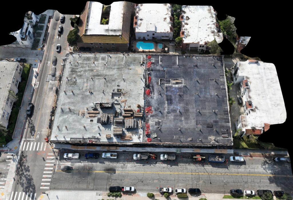
In commercial construction, photogrammetry is the process of capturing overlapping aerial images with a drone and using specialized software to convert those images into accurate 2D maps, 3D models, and measurable datasets such as orthomosaics, point clouds, and digital terrain models.
Instead of simply viewing a jobsite, teams can:
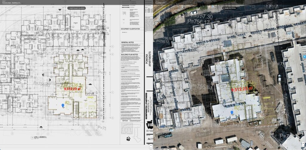
- Measure distances and areas
- Calculate volumes
- Compare time-based progress
- Document site conditions with precision
It transforms imagery into usable construction intelligence.
How Photogrammetry Supports Commercial Construction Workflows
From our experience operating pilot and visual observer crews across Southern California, photogrammetry provides the most value when it is integrated into repeatable reporting cycles — not treated as a one-off flight.
Here’s where it most often supports project teams:
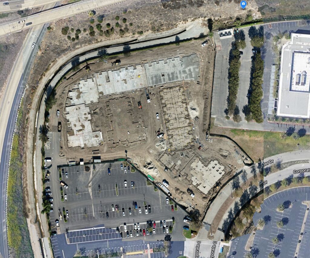
1. Preconstruction & Existing Conditions
Photogrammetry provides a detailed baseline before work begins. This helps align owners, designers, and contractors early — especially on complex or urban sites.
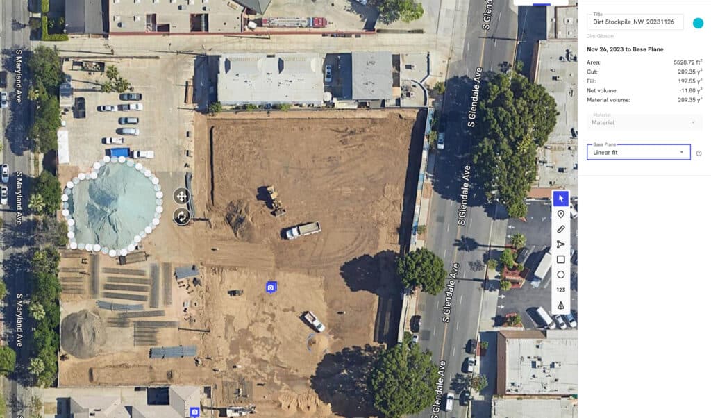
2. Earthwork & Volume Verification
Accurate volume calculations help validate grading progress and reduce uncertainty around material quantities.
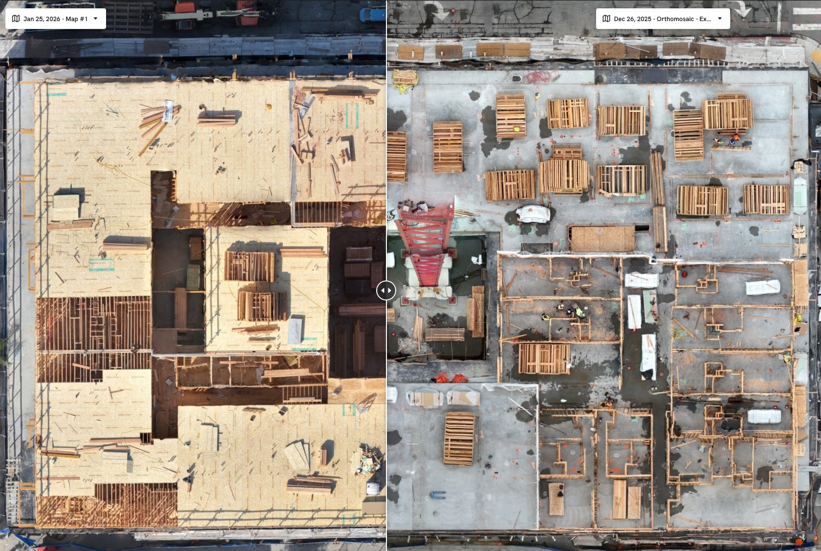
3. Progress Validation
Side-by-side comparisons allow project teams to visually confirm sequencing and identify potential inefficiencies before they escalate.
4. Executive & Stakeholder Reporting
Measurable orthomosaic maps and 3D models create a structured reporting layer that most executives find easier to interpret than narrative-only updates.
What Photogrammetry Produces
A properly executed photogrammetry workflow typically generates:
- Orthomosaic maps (georeferenced 2D aerial maps)
- 3D site models
- Point clouds
- Digital Surface Models (DSM)
- Digital Terrain Models (DTM)
- Volume calculations
These deliverables allow teams to move beyond visual observation into measurable validation.
Photogrammetry vs Standard Drone Video
| Category | Drone Video | Photogrammetry |
|---|---|---|
| Emotional Impact | High | Moderate |
| Measurability | None | High |
| Progress Comparison | Limited | Structured |
| Volume Calculations | No | Yes |
| Reporting Value | Visual | Data-Driven |
| Dispute Support | Weak | Strong |
Video may support marketing.
Photogrammetry supports management.
Most commercial stakeholders prioritize measurable outcomes over cinematic visuals.
Mini Case Snapshot (From Field Experience)
- Project Type: Mid-sized commercial development, Southern California
- Challenge: Grading quantities required validation before pay application review
- Drone Method: Recurring photogrammetry flights producing orthomosaics and volume calculations
- Outcome: Improved confidence in reported quantities and clearer owner-contractor alignment
Why Photogrammetry Strengthens Risk Control
In our work supporting commercial construction teams, we’ve seen photogrammetry reduce risk exposure in several ways:
- Early identification of sequencing inconsistencies
- Documentation of scope changes
- Visual confirmation of installed conditions
- Reduced ambiguity in progress conversations
When teams rely less on interpretation and more on measurable site data, decision cycles tend to accelerate.
And accelerated decisions often protect margins.
How Photogrammetry Fits Into a Modern Drone Program
Photogrammetry is most effective when it becomes a repeatable intelligence layer across the lifecycle of a build:
- Monthly mapping cadence
- Standardized flight plans
- Time-stamped archive
- Executive-ready reporting structure
When structured properly, photogrammetry is not a technical add-on.
It becomes operational infrastructure.
FAQs
Is photogrammetry accurate enough for commercial construction projects?
When properly captured and processed, photogrammetry provides reliable site measurements suitable for progress validation, documentation, and volume analysis.
Does photogrammetry replace traditional surveying?
No. It complements survey data by providing frequent visual and measurable updates between formal survey milestones.
How often should photogrammetry flights occur?
Most commercial projects benefit from monthly flights, with higher frequency during critical grading or structural phases.
What software is used for photogrammetry processing?
Professional workflows use specialized processing platforms that convert overlapping images into orthomosaics, 3D models, and terrain datasets.
Who benefits most from photogrammetry?
General Contractors, Owners, Developers, and Project Executives responsible for oversight and reporting.
Executive Takeaway
Photogrammetry in commercial construction is not about capturing better images — it’s about converting site conditions into measurable, defensible data. Most construction stakeholders prioritize clarity, risk reduction, and validation. When integrated correctly, photogrammetry provides all three.
From The Editor:
Do you need to hire a professional drone service provider for your project? To speak to an aerial data specialist, fill out a form, email us or for even faster response times, give us a call at (833) FLY-4YOU or (833) 359-4968. Check out our transparent pricing at https://aerialdecisions.com/drone-photography-pricing/ and watch this space as we expand on the above topics and more over the coming weeks and months.
If you like this post, feel free to click the share button at the bottom of the page. We appreciate you helping us by spreading the content we share on our blog.

Showcase Your Company on the Drones and Construction Podcast! If you’d like to be a featured guest on our podcast, send us an email: info@aerialdecisions.com and one of our crew will get right back to you to share the details.
About Aerial Decisions
Aerial Decisions is a Los Angeles-based Drone Services Provider (DSP). We specialize in providing cutting-edge drone data collection combined with industry leading software solutions tailored for the commercial construction industry. Our mission is to optimize the way enterprise construction projects are managed by offering precise aerial photography, detailed data analysis, and innovative software tools through a network of FAA-certified and insured drone pilots. Aerial Decisions is not just a drone service provider; we are your strategic partner in commercial construction. Our hands-on approach to understanding your unique requirements and our dedication to excellence ensures that every flight and every data point is optimized for your success. Trust us to be the eyes in the sky that elevate your construction projects to new heights.